The Elevator That Begins on the Street
A subway station can have many ways in and only a few step-free routes to a particular platform. New York’s 14th Street project shows why each elevator is a link, not the whole trip.
In this story 5 sections
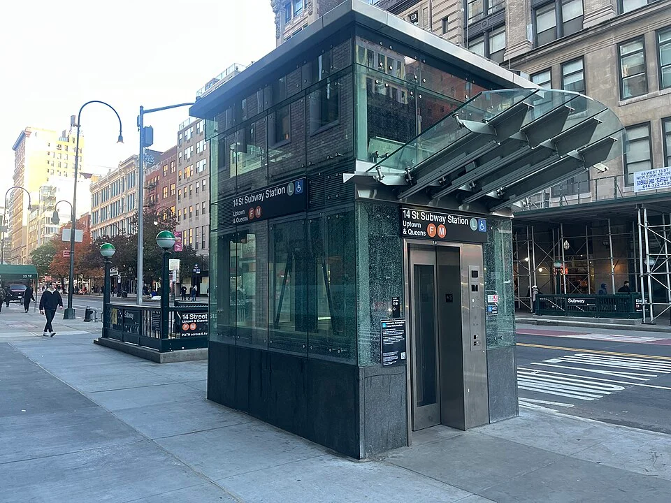
The photograph taken at 14th Street and Sixth Avenue shows two ways of going into the ground. The elevator has a small glass building of its own. The stair entrance beside it leads downward as soon as someone crosses its threshold. Both belong to the station, but only one offers a particular kind of entrance. If a map put a single station marker somewhere in the road, it would give a reader no way to distinguish the two doors.
New York's Metropolitan Transportation Authority described a sequence of elevator installations at the 14th Street complex, serving routes and platforms reached from more than one avenue. A 2024 photo can show what a new entrance looked like at one stage of the work. It cannot establish today's pathway, whether a given lift is running, or which links have subsequently opened. Use the authority's current station and status information for those questions. The old photo is useful for something more durable: noticing where the trip begins.
Map a corner rather than a station name
A station name is an economical way to put a whole place in a timetable. It may be less useful to a person at street level. At a wide intersection, a stair at one corner and an elevator diagonally opposite involve different crossings and waiting times. A passenger arriving from a nearby bus may already be on the opposite side from the appropriate elevator. Knowing the station is ahead is not the same as knowing which curb provides the route.
An agency can give a corner, an address or a landmark, as long as the description is recognisable from the approach. It is worth considering both directions. Instructions that name only the shop immediately behind an elevator may be hard to use when the shop is obscured from one crossing. An instruction with a compass corner needs a person to establish which way they are standing. The strongest description combines a reproducible location with something an arriving passenger can see.
The photo's glass enclosure is prominent. Even that detail helps only within a useful distance. If a person has already crossed the wrong street by the time they can make it out, the cost of an incomplete map has been paid. Station plans, transit notices and signs approaching the intersection all have a chance to supply the information a little earlier.
A basement does not contain a single destination
Consider a fictional station with a street elevator down to a mezzanine. From the mezzanine, another elevator reaches one platform. A separate lift reaches another. In such a place the first elevator has done an important job without reaching every train. Someone can arrive at the mezzanine and be unable to finish their transfer unless a lift connecting the remaining levels is working. A system described with a list of assets needs a route drawing to make this plain.
The MTA's description of the 14th Street project names different platform connections introduced in stages. The distinction is useful without memorising the construction timeline. Access to one direction or one line can change before other parts of the complex do. A reader who needs to make a specific trip should check the station, direction or transfer under discussion rather than infer from an opening announcement that the entire complex changed at once.
A model for this is a line with three named points: street, fare area and destination platform. A line connecting them could pass through more levels. A station might have two ways to reach one point and just one way to continue after it. Take any connection out of the drawing and check whether another complete line remains. Knowing there are numerous elevators is encouraging; knowing which pair reaches the actual platform is much more useful.
The notice can identify the broken link
The MTA maintains a page showing elevator and escalator status and provides ways to report outages. Its instructions ask for details such as the time, station and equipment number. This makes sense in a complex where more than one piece of equipment shares the same station name. A user may report the right station but the wrong connection if the only available description is the elevator near the entrance. A visible number can link the observation to the asset actually in view.
The next practical question is where an alternative starts. An unavailable street elevator can require somebody to make a change before entering the paid area. A problem elsewhere may become visible only after the traveller has reached a mezzanine. A message about another route should not assume the reader stands at street level when the reader actually faces a set of stairs below it. Specific notices can name the affected levels as well as the name of the station.
An alert also ages while people travel. A time and a current official source help someone tell the difference between an update and a saved screenshot. A visitor might have read the page before setting out and see another notice when arriving. The public information should connect the two by identifying the same equipment or route. If the only available message is a generic failure notice, staff assistance and official routing information may be necessary to work out the usable alternative.
A complete wayfinding test starts before the kiosk
A transit operator or station planner can ask a person to follow instructions from a typical arrival point to a named platform. The first few steps matter. If the reader walks away from the correct street corner, getting the rest of the station plan right will not fix that first mistake. If the reader sees the kiosk and then cannot tell which stop or level to select, the problem has moved inside. Those are different findings that can be recorded as the trip proceeds.
People travel for different reasons and have different familiarity with station names. A rider who uses the same entrance each day may recognise a site by its glass structure. A visitor has only a line, a station label and the direction a sign supplies. A helpful test allows both to use the route. It also records whether each direction is independently clear. A journey that works going in may give poorer instructions on the way out, when a rider is trying to select a specific street exit from below.
It can be valuable to make a second trip under slightly different circumstances. A sign legible when a sidewalk is empty can be hard to see when a queue forms. An off-hours entrance rule can affect the passage even though the equipment itself is working. The design question is not just whether a person can ride from one floor to another. It is whether they can find and complete the intended trip without already knowing the parts of the route the map was supposed to explain.
Keep the entrance and the destination in one account
A complete station diagram should also distinguish a way out from a transfer between lines. A traveller leaving a platform may be following a route that ends at the surface. Someone else on the same platform may need to reach another line without leaving a fare area. Both might use one lift, then have different destinations after its doors open. The information at the junction has to place those destinations in front of someone rather than wait until they have already passed the parting point.
There is also a useful difference between a route with a direct replacement and a route that can be recovered only by using another station. Suppose one lift becomes unavailable in the fictional complex. A second lift might lead to the same level from the other end of a corridor. If none does, the official alternative may involve a different entrance, station or mode. Listing an alternative by name alone does not make clear how much of the journey changes. A notice can help by identifying the link that is out and the point at which the revised trip should begin.
The photo shows why the street location should be kept even in a simplified diagram. An entrance marker and a stair marker do not occupy the same approach space, even when the two installations are in the same photograph. The exact corner can matter more to a first visitor than the distance between stations shown at a much larger scale. A good station description can zoom from one account to the other without losing the link between them.
A street photo is a useful place to start because a rider's problem sometimes starts exactly there. A system map can draw train lines dozens of kilometres long. The useful drawing for the next minute may cover only a corner and the approach to a doorway. Continue that drawing until it reaches the right platform and add the conditions that can change on the day. This is how a familiar word such as accessible becomes specific enough to plan around.
The little glass structure is an entrance to a particular path, not to every destination a station name can suggest. Giving it a precise location helps a first visitor find it. Giving the onward path a precise description helps that person finish a trip. The rest is keeping those descriptions usable while the city above and the railway below keep moving.