When the Street Is a Staircase
Pittsburgh’s public steps connect streets at different elevations. Keeping a stair route useful calls for addresses at both ends, plans for closure and a map that makes the climb visible.
In this story 5 sections
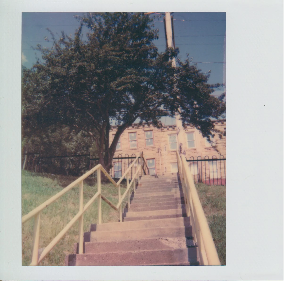
The O’Hern Street staircase in Laura Zurowski’s photograph can be read from the bottom up. Railings lead the eye into the frame. Above them sits a landing and, beyond it, the ground rises farther. Much of what a pedestrian will have to do is visible before the first step. Draw that same connection on a conventional street map and it can be reduced to one short stroke. That stroke might join two points so close together that a person would expect to cover the distance in a minute. The elevation between those points makes the line a different proposition.
The photograph records one staircase in Pittsburgh’s Central Northside. It isn't an inspection of the present condition of that staircase. Pittsburgh maintains a citywide inventory of public steps and treats them as part of its walking network. The city's information distinguishes staircases built on independent structures from steps built into sidewalks. The two can look similar to someone walking or scrolling a map. For the people responsible for the connections, they make different demands on the budget and on the way a repair can be carried out.
Short on a map, useful in real life
A route down a hillside that makes sense for a pedestrian need not follow the same pattern as a road. The road may take advantage of a gentler grade by winding around the slope. A stair linking two levels might cut straight across the intervening ground in a much shorter horizontal distance. A resident who can use the staircase might reach transit or a shop on foot in a way a driver would not choose. The stair does not have to lead to a landmark. Connecting two ordinary sidewalks can be the useful thing it does.
For a daily trip, the time and effort of crossing a hill count together. Imagine a worker traveling downhill to a bus in the morning. The same steps are an uphill trip in the evening. A short link from above to below can be a deliberate choice in one direction and something to avoid in the other, particularly when someone is carrying groceries. To a map drawing they are the same connection. To the pedestrian they are two routes with different demands. A staircase on public land can belong to the network without being the right route for every person using it.
This matters when comparing the visible line with an alternative. The line might appear to duplicate a road that passes close to it. On the ground, the nearest alternative may reach a different crossing or require a return along the lip of the hill. A good inventory puts both ends in context. One should be able to check from the map which sidewalks the staircase connects and how far a closure would send someone before they reach another suitable way between those levels.
Give the staircase two addresses
People can refer to the top of a flight and the bottom on different streets without disagreeing about which staircase they mean. A resident might know the name of a road on their side of the slope and rarely have an occasion to use the name on the far side. A repair request that uses only a stair name or a nearby house number may send a crew to the wrong end. The cost of the error is tangible. Even if there is a quick path for a person without equipment, a vehicle cannot necessarily reach both entrances from one approach.
A maintenance record can join names to map coordinates and include an unambiguous description of the portion in need of attention. For example, “the third tread down from the uphill entrance” supplies context that “the third step” leaves out. Note the difference between identifying an entire staircase and identifying a problem within it. An address at the bottom might locate a staircase perfectly while still leaving someone to look for a loose rail for the full length of the climb. Pittsburgh's published guidance asks for specific location details for reports about steps and related problems. A practical record should make it possible to update the condition without changing the staircase's identity.
There may be a gap between what files call a link and what a sign says at one end. A route cue can work without a long description if it gives the corresponding endpoint or the staircase name used in the inventory. Include where the staircase goes and how the next street can be recognized. Someone already acquainted with a neighbourhood may be able to fill in what the sign leaves out; a visitor making one trip has no such advantage.
Distinguish a tread from the structure beneath it
The Pittsburgh guide describes jumperwalks, where steps are built into a sidewalk, as one part of the inventory. Other staircases sit on structures. That distinction matters as a maintenance issue. Replacing the surface of a low section that follows solid ground is one kind of project. Repairing a run that carries people above a slope may involve assessing the load, checking what is supporting it and arranging access below. A picture from the top can make the parts a person steps on easy to see while concealing how they are held up. The city explicitly compares work on some structural sets of stairs to a small bridge project.
Problems also arrive at different scales. Vegetation might make one approach difficult to see. A missing light can affect use after sunset even if the staircase is sound. A defect in the support has more consequences than an unclear sign and requires a different response. A short public report can help distinguish the observed effect from its cause. State where something is hard to see or where a tread looks damaged; leave the assessment of the structure to people equipped to make it. Different pieces of the city's work may be needed, but the starting location can still be the same.
A plan can consider the value of a stair without assuming all its defects take an equal amount to fix. The city describes setting priorities using study, public input and field visits. The issues that surface that way are not interchangeable. One staircase could have a readily available detour but need substantial work to reopen. Another might be in a condition that is relatively simple to improve yet provide the only reasonably short connection between a pair of streets. Making the comparison explicit makes the repair programme easier to understand from outside the office.
Plan for the day the shortcut closes
A stair can appear on a map while it is unavailable on the ground. When a caller sees that discrepancy, the problem goes beyond recording its formal status. People need to know whether the closure applies to the whole connection and where another route begins. A sign near the bottom might be too late for someone approaching from the street above. A notice at both ends and an update to an online map will reach people at different stages in their trip. They can say which streets the closed connection would have served and where to resume a journey by another way. Any route shown as an alternative needs to be examined as a real route, with crossings and slope as well as distance.
Sometimes the closure of a stair does not affect the closest step-free option because they were already different routes. It still matters that the map distinguish them. Calling something a pedestrian detour says little about whether a person can complete it with a wheelchair, pushchair or a load on wheels. A stretch that avoids steps can have a difficult grade, awkward crossing or another impediment. The words usable here must refer to conditions a person can check rather than to an assumption that any line open to pedestrians will do.
There is a related difference between a project's timeline and a useful sign. A project page can tell readers what design or construction stage has been reached. A sign at an entrance has to make the immediate condition legible, even if an opening date has not been established. People will make a sounder decision with a clear present statement and an alternative route than with a stale date for a reopening that did not happen.
A street with its height restored
Return to the two railings in the photograph. They mark a visible passage through the part of the hillside that a map usually measures only from above. A pair of street names would help somebody find it. A profile in elevation would show why it is useful and why it takes work to keep it open. An inventory can hold both descriptions at once, along with a record of which part a crew has to reach and what a pedestrian must do while it is unavailable.
There is a particular benefit in treating a public staircase as transport. Its name, status and connections belong in the set of facts a person can check before leaving home. It can be a valued part of a neighbourhood and a small, routine piece of the city's responsibility at the same time. Above all it needs to stay legible as a route from one familiar place to another, even in the moment a visitor's first step brings the vertical part of the map back into view.