A School Street by the Clock
A timed school street changes the approach to a school for part of the day. The right questions start at the sign and continue around the surrounding blocks.
In this story 5 sections
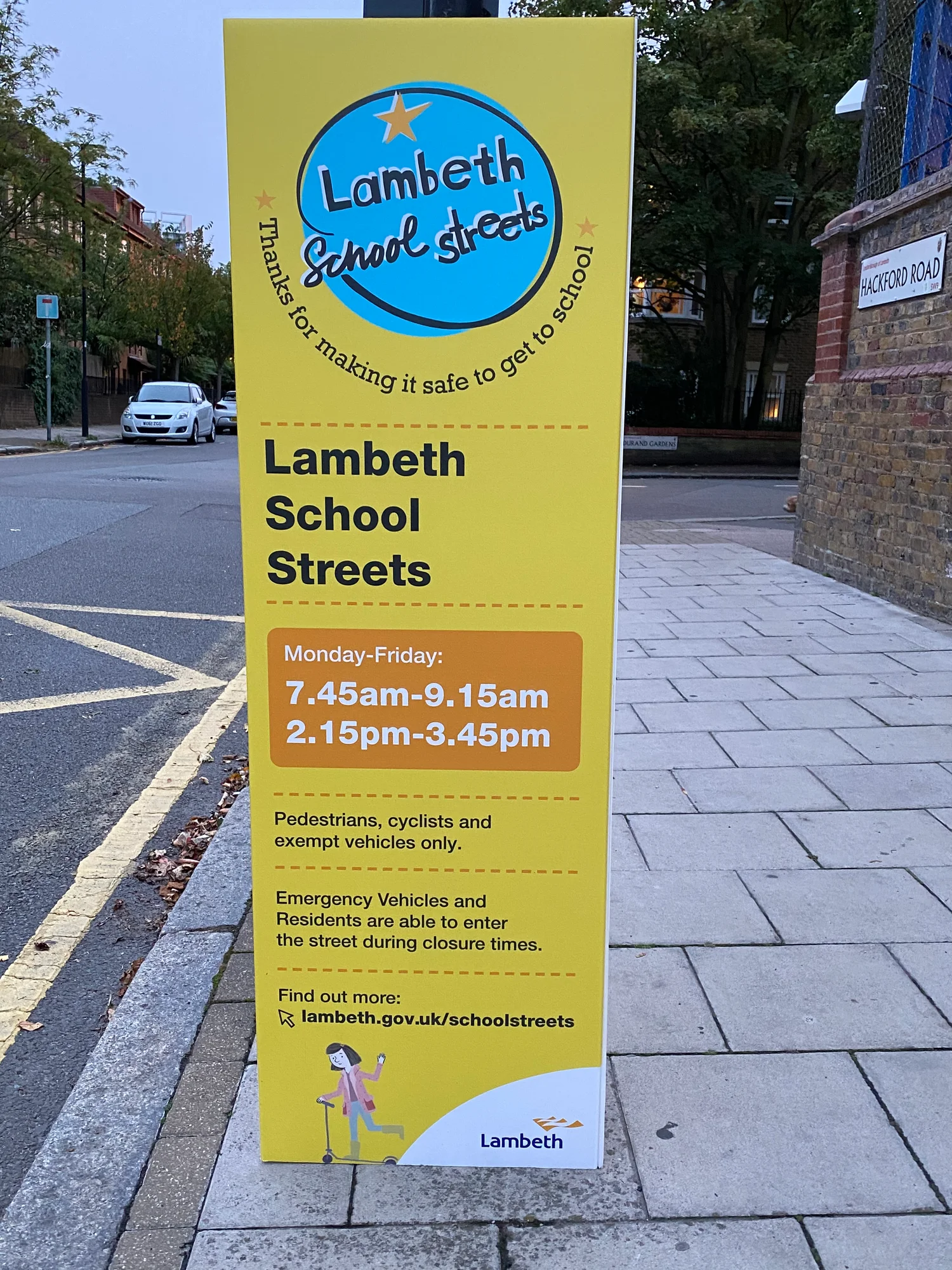
At the threshold of a school street there may be no visible change in the paving. The houses keep the same front doors. There is still a street down which a person can see all the way to a bend. What may be different is a notice at the point where a driver would enter it. Read the hours beneath the principal sign and you will learn when the restriction is meant to apply. Then comes a question rarely answered by the photograph of the sign: where, exactly, is a person who travels by another route going to meet the same change?
In London a school street commonly involves timed restrictions on motor traffic near a school around drop-off and pickup. The idea is to improve the conditions of the short journey to the gate at the times when many children make it together. Local authorities publish site-specific arrangements, and the times, boundaries and exemptions may vary. A dramatic view of an unoccupied street is not the only way a scheme can work. Nor is an ordinary view in the middle of the morning evidence it has ever been in effect.
Give the proposal a perimeter
The obvious center of a school street is the gate. For traffic, the most consequential part may be somewhere else: a junction at which a vehicle would have to turn before reaching the restricted stretch, for example. A map should let someone point to the actual entrances to the area, including an entrance into the middle of the zone from a side street. At a quiet desk you can trace a circle around the school and imagine a uniform change. On the ground the access network attaches to it in a small number of particular places.
Lambeth’s published map for St Andrew’s Catholic Primary School is a useful example of an official document that makes the extent legible. Read the line on the page, find the named roads and locate the points associated with the signs before thinking about the rule in terms of a distance from the gate. The map can help answer whether a route toward a school intersects a marked entrance. It cannot tell you by itself whether the restriction is active at a given time or whether an access arrangement applies. The council’s list of schools, hours and locations serves a different job.
A timed restriction does not usually have to be announced at every point inside the area in order to change what happens at the boundary. But someone going to a front door or shop near it might need notice before reaching the place where they have to choose another turn. The useful advance notice, if one is appropriate for the site, can be at a distinct location from the official restriction sign. Mark both on a sketch. People discussing signs in a meeting might otherwise agree that there is a sign without talking about the same place.
The minutes are a design choice
Suppose a fictional school’s greatest congestion is just before eight fifty in the morning. A diagram of the street cannot establish whether the useful restriction begins fifteen minutes before that or much earlier. A worker serving breakfast at the school, parents bringing children on a staggered schedule and people making deliveries have different reasons to arrive earlier. Watching for a whole period around the gate, rather than selecting the busiest looking five minutes, offers a better picture of which movements the proposed change would affect.
A timed window may also expose an awkward gap. If the last crowded part of pickup comes after the restriction ends, the effect is striking to someone standing outside and hard to detect in figures reported for the restricted period only. Some families may choose alternate arrival times after a change. That is valuable evidence, though one observation on a day with a special event cannot tell you whether it is a lasting change. Record the school timetable for the days in question, plus broad conditions such as whether it was raining. Timing is part of the event as well as the rule.
Different readers ask different questions of the clock. A resident may need to know whether a particular trip can be made at all at its original time. A caregiver using the bus might want to know whether the crossing from a stop is easier. A school employee wants arrangements for deliveries clear enough to plan around. Collect these as distinct experiences. It helps when a claim that “the hours work” is followed by whose journey was considered and over which part of the morning.
Observe the next block, too
A nearby block may receive some of the activity that used to concentrate at the gate. There are several ways this can look. Drivers may use a different street only as a through route. They may stop temporarily and passengers may walk the remaining distance. Some whole trips may switch to walking or cycling. Counting vehicles passing in front of the school does not distinguish among these possibilities. At a minimum, use a consistent description of what is being counted and where, then choose comparison points at which the differences could matter.
A practical sketch puts a mark where the restriction starts and one where a child would normally cross. Add the places people stopped in the corner of your view and any separate nearby street where a similar question arises. You may see a notable improvement at the gate and an ambiguous result near a bend. Write both. The bend could become a separate issue for investigation, or the activity may prove to be usual there. Without a baseline from before the change it is hard to be certain that a noticeable event is new. Other landmarks, such as a building entrance that has changed use in the meantime, may help explain a less tidy result.
A count of people crossing or passing can be made without keeping faces, names or vehicle details. The issue for a simple street review is usually the movement and how it affected the place. Someone standing outside a school observing should respect the school’s arrangements and use a safe ordinary place to wait. Notice whether you could actually see both approaches from where you stood. An absence in your notes may represent an absence from your view. Good observation is explicit about that limit.
Access also has a route
Any stated exemption belongs to the actual policy, and particular trips can depend on how it was written and administered. Talk to people who use an entrance before assuming they all have the same choices. An accessible journey may depend on a place close enough to a door or on being able to use a particular surface. An eligible resident may have two ways to show that they can use the road, or there may be a process they need to complete in advance. It is the council’s arrangements and signs in effect that determine the answer for that location. A case study from another borough can suggest a question to ask without providing the answer.
A short, useful explanation of a proposal follows a trip all the way through. Who starts at point A? Where will their choice first change? If they need to make a special arrangement with the authority, where can they find the current information? How will they know if the period has ended? An explanation that stops at “the school is inside the zone” asks many readers to solve the same route puzzle on their own. The people most affected by the details are often the ones least served by that shortcut.
Make room for the return journey in that explanation. A person may arrive before a window and need to leave after it begins. Another may be able to walk part of the way in the morning and need help in the afternoon. Where the direction of travel matters, an arrow on a map and a note about which movement it stands for can prevent a surprising amount of misunderstanding. Count policy, network and timing as separate pieces until you have established how they actually fit together.
Ask a modest question of the first report
After the initial period of operation, the most useful report may answer a claim of limited size. It could say how a measured activity at a particular gate differed over comparable periods. It might include surrounding roads and a description of who was consulted. Information on changes in mode of travel, pollution, traffic conflicts or accessibility would need the right observations for each claim. An appealing first photograph should take a smaller place in such a report than a clear account of where people counted and when.
Return to the sign a second time outside the restricted hours. The view may look almost identical. The change is something you have to place in a timetable, among real routes and at several sites on the ground. That ordinary-looking sign can make an important difference to the front of a school for an hour. To find out how, give the people beyond the frame the same attention as the people already at the gate.