What a Tree Inventory Calls One Address
Two trees can stand in front of the same building and require different work. A public inventory needs a way to identify the individual tree without losing sight of the street around it.
In this story 5 sections
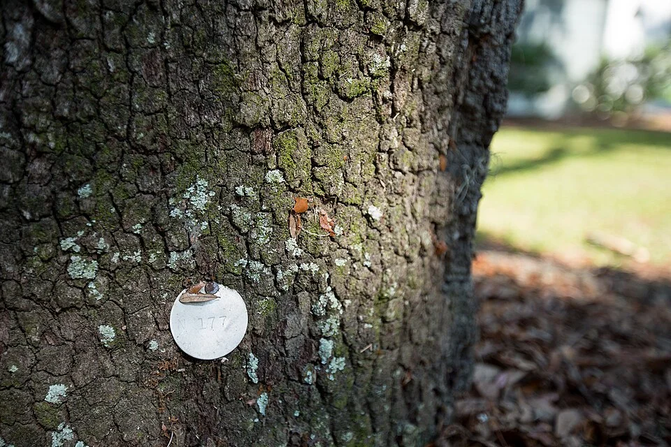
The round tag in a photograph published by North Charleston is smaller than the light patch of bark around it. A closer view shows that it carries an identifying mark. It is a quiet kind of sign because it has very little to say to someone who has never seen the associated record. It doesn't identify the building beside a tree or promise what somebody will do next. It gives a person a way to refer to that particular tree later. At the time of a survey that can be a more difficult job than writing down the address closest to it.
A city street can contain two or more trees in front of one building. A tree could instead stand near the corner, where people coming from two directions would use different addresses to describe the same place. NYC Parks has written about the care its street tree census put into connecting trees to the nearest buildings so surveyors could find them again. New York's inventory is a separate example from the tag in the photograph. Together they show why a public record can benefit from an identifier for the tree and a description of where it stands. Each solves a part of the problem the other leaves open.
The address is useful even when it isn't unique
Imagine a long building with two entrances on different parts of the same street. There are three trees between them near the curb. A resident might report a branch over a path by giving the number at the nearest door. A surveyor might register all three under that same number, as it is the building address nearest them. Either description gets a person to the approximate place. Neither gives a new visitor a sure way to find the particular tree until there is a point on a map or a description such as second tree from the corner.
Now imagine a row of younger trees along the same block. Several look alike at a distance and could all have the same recorded species. Location and species both help, but it might still take a more particular record to decide which one was measured at the previous visit. A map point, a short description and a unique record number answer different needs. A resident might be able to give the description quickly. A worker holding a list of earlier measurements might need the number to make sure the histories do not get joined to the wrong trunks.
Even a precise-looking point can deserve verification. The building may be mapped at its centre while the tree sits several steps out toward the street. A dot drawn just east of a door could look like a dot west of it on a very small mobile map. Landmarks and directions remain helpful alongside coordinates. A description such as on the south side of the street east of the crossing survives a change in how a building's address is printed, if the position itself hasn't changed.
A tag refers to something that can change
A survey records the tree as it can be observed on a particular date. Species, size and condition belong in that record in different ways. Some characteristics are expected to change. A measurement taken several years apart can show growth, and a condition description after work cannot simply replace every earlier observation. Keep the identifier stable when people are following one tree through those changes. Otherwise an update can make it look as if a different tree appeared at the same place every time something about the record changed.
Replacement is another kind of event. A new tree can occupy a position close to where another one once stood. The planting location persists while the living thing in it changes. For a city interested in work at that location, it can be useful to connect both records to the site. For people following the performance of the original tree, it is equally useful not to treat the new trunk as though it inherited all of the older one's measurements. The address may suit both records; the identity of the individual tree cannot.
A physical marker can also become difficult to read or be absent on a later visit. That is one reason an inventory should not depend entirely on a tag someone has to touch or approach closely. A record can describe other evidence and give the team an appropriate way to report a mismatch. The photograph shows a tag on bark, not that every tree in a public census receives one. Some inventories can let people look up a mapped record without finding a separate numbered object on the tree at all.
Consistency helps more than a large number of fields
NYC Parks describes the earlier census as recording such properties as location, species, size and condition. Measuring at a defined position or using the same broad categories makes later comparisons easier. Even a plain field such as diameter is easier to interpret when it is accompanied by how and when it was recorded. A map user does not have to see every technical detail to find a tree. The details are useful when the office reviews a whole street or asks what changed between visits.
Consider two officers or volunteers taking descriptions at different times. One might use the shop name and another the building number from an entrance around the side. Their individual notes could both be accurate and still produce two apparent locations in the combined list. A shared way to assign positions helps people match their work. It is better to specify which side of a corner counts and how the position was established than to ask someone at a desk to repair every disagreement after the fact.
The same applies to naming. A common name may be familiar to a neighbour and have several possible meanings to someone managing records. A field with a standardized identification and a displayed name useful to a resident can work together. If an identification is uncertain, say so. A precise label invented to fill a blank may be more difficult to correct later than an honest mark recording what the observer could determine at the time.
Give the public map a job people can see
A person looking up a tree may only want to know what it is. They might also want to send a service request or check a detail about a recent visit. Distinguish the tree's identity from messages about those additional services. A map dated for a past survey might still answer where a tree was recorded without representing its current condition. A record of work performed can provide useful context without showing what merits attention today. Readers should be able to tell which date belongs to which line.
New York’s individual tree pages show what a mapped entry can look like. The useful idea is to give one object a place a reader can return to. A public view need not expose internal notes or the personal details of anybody who made a report. A resident can name the tree, give its location and describe the issue they observed. The people receiving that report can then use the identifying information to find the appropriate record or investigate further. Neither has to assume that an entire block of similar trees is being described.
A map can also help when a record is missing. A person who finds the nearest mapped tree should not be encouraged to attach every report to it if their observation concerns another tree nearby. Choosing a location and describing a gap can be better evidence. The possibility that the map or address is imperfect is a reason for a usable way to update it. It need not make the inventory useless.
There is an additional use for the gaps themselves. A street plan looking for places to plant needs to distinguish good unoccupied positions from missed records and empty spaces that cannot be used. A blank region on a screen can stand for any of those things. A field visit can put the reason for a gap beside the position. The next person studying the same stretch benefits from knowing that there is an established tree on one side, an empty but usable site on the other and a place in between where the map was simply incomplete when published.
Keep the tree and its place in view
The tiny disk in the photo has value because it can link work done at different times. Its number is not an address a visitor would recognize by walking along the pavement. The position near a building or corner is not always an identity for one tree. Put those things together carefully and a report can concern the intended tree, the condition actually observed and the right visit in a sequence.
Next time a row of trees seems uniform from across a street, look at the gaps among them. They can show why a reference to the shop behind the row is an excellent way to get someone close and a poor way to tell them where to stop. A city tree record becomes most useful when it can do both of those jobs and keep doing them even after the street looks a little different.