The Passage Through a Private Building
A publicly accessible passage can run between privately maintained walls and still work as part of a bigger trip. Manhattan’s 6½ Avenue shows why openings and hours matter block by block.
In this story 4 sections
One route between numbered streets in midtown Manhattan runs surprisingly close to the buildings that contain it. A passage can be wide and high enough to feel obvious once somebody is in it, then look easy to miss from the street. The entrance can sit near doors intended for a business. A traveller needs to know which way is available for public passage before deciding whether to turn. A path that is legible on a map is doing only half that work.
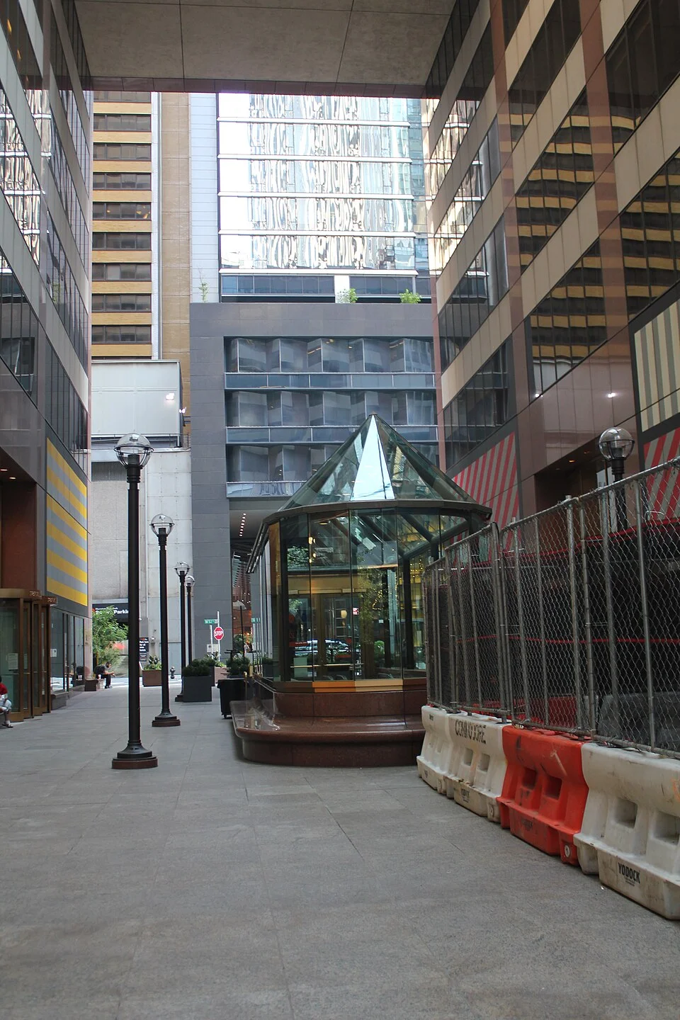
New York City's transportation department described its 6½ Avenue project in 2012 as connecting public spaces with marked midblock crossings between West 51st and 57th Streets, between Sixth and Seventh avenues. The photograph shows the setting of a passage at the AXA Equitable Center in 2021. It identifies a piece of the route at a moment in time. The city's material explains what the larger project intended to connect. A person making a current trip would still need the current entrances and any applicable hours.
A space can be public by arrangement
New York City Planning describes privately owned public spaces as areas dedicated for public use while privately owned and maintained. It identifies zoning incentives as part of the origin and operation of the program. A visitor seeing a lobby door or a glazed walkway cannot determine from appearance alone whether it belongs to this category. Nor should the citywide description be treated as a promise that every site has the same schedule and rules. The relevant location, city record and posted information describe how the particular space is provided.
The name can be puzzling because the two words answer different questions. Owned asks who is responsible for the property. Public describes a use the designated space is there to offer. The person looking for a place to cross needs to know what ground, door or passage the designation covers. Not every entrance to the same building necessarily leads to the shared space. The threshold is where the distinction should be made visible without requiring the visitor to recognise the shape of a legal arrangement.
A site can add other things within or along the space: places to sit, plantings or a business mentioned in the city record. None should make a pedestrian assume a purchase is the only way to stand inside a designated public area. Conversely, looking into a privately operated room does not establish that it belongs to the public route. Signs and plans can locate the relevant boundary, even when it does not correspond to a difference in material on the floor.
Several short passages can become a route
The DOT release explains that the 6½ Avenue project connected several existing public spaces with crossings on the intervening streets. The process is easier to grasp as three different links: through a block, across a street and into the next block. Each can require a different kind of provision. There may be a public entrance, a marked pedestrian crossing and another public entrance. Drawing a long line through the middle does not explain who can provide those links or what happens when one is inaccessible.
A small gap can matter disproportionately. Suppose a fictional through-block path leads directly to another entrance across an ordinary street. If there is no clear way to cross between them, the two well labelled passages still do not operate as a continuous shortcut. If the crossing is clear but the next entrance looks like an employee door, the issue moves from roadway to threshold. The city's original description focuses on work in the street because that was one of the elements needed to join existing spaces. It did not have to create every passage from nothing.
The shape of the route can matter in the other direction too. A person arriving from another block may not recognise a route name used on the previous sign and might need to look back to see where the turn is. A wayfinding system that works only with the designer's usual approach is incomplete. As with a shop entrance or an access ramp, the test starts before the decision needs to be made, from more than one direction of arrival.
Hours belong to the link as well as the destination
NYC311 explains that some designated spaces are available at all hours and others have approved closures, and that sites carry public signs about hours and features. Hours matter differently when a visitor wants to sit in one space and when they need to use it on the way to another place. A passage unavailable at the planned time does not merely remove a place to pause. It can make the rest of the route irrelevant unless a nearby alternative is understood.
Suppose an evening walk is being described on a simple map. A map editor can show the existence of a passage without implying current operation at that hour. Add a dated reference for hours and distinguish the public street sections from doors in buildings. If a rule applies to a particular entrance, make the entrance identifiable. The label closed at night is too broad if the only question is whether a visitor can follow a precise path at a particular point in the evening. Actual trip decisions need the city and site information that applies at the time.
It helps to put the public notice where a person can read it without committing to the passage. If a gate is closed, there may be no point in directing someone toward a sign on its other side. A sign at a junction can give enough information to choose another path. The same idea applies to a temporary closure. The practical goal is to let a visitor revise a journey before a newspaper-length explanation of its cause has become necessary.
A useful report says which part did not work
It can help to document the continuity of the trip at the same time. Make a small line from one named street to the next and identify intervening entrances. Mark which places are private spaces with public access and which are on the street itself. A reader should be able to distinguish an ordinary street crossing from a turn whose availability depends on opening hours. This is useful for anyone comparing a map with their experience. It can also allow an operator to identify whether a closure notice should affect one block or warn someone before entering a longer chain.
Different users notice different gaps. A traveller who has used a passage for years may never look at its entrance sign. Someone using it for the first time might assume it belongs only to a building with security at another door. A person who needs a step-free path may want to know whether the level changes between the two publicly accessible parts. Report what was visible and usable from the actual approach. A route that only works for the person who already knows it is offering fewer public choices than its line on the map suggests.
One more comparison concerns a pass-through and a place to stay. They can share a space without making the public's needs identical. A person cutting through at lunchtime values a continuous clear line. Someone taking a break values seating placed where a passing crowd does not make it hard to sit. The citywide description includes public spaces that support a range of uses. At any particular site the list of features and the quality of a through route can therefore be evaluated separately. Counting seats gives no information about whether the door to the next block can be found. A conspicuous opening does not explain how to get to a seat inside.
NYC311's instructions describe ways to report certain problems in a privately owned public space, such as closure during posted hours or missing amenities. Their requested details include the posted time and what condition was observed. The approach is sensible for a route with several parts. Describing an inaccessible door at a named address on a stated day is more useful than reporting that a whole passage system looked closed. An official complaint process still has a defined scope; it is not a substitute for general information about every aspect of a building.
An observation can be precise without stating a cause. A door was closed during an interval posted as available, or a sign could not be read from an ordinary approach. Those facts can direct an inquiry. The reason for the condition might involve a temporary arrangement, an error or a responsibility needing to be clarified. A good report leaves those explanations open while giving staff enough information to identify the matter.
Describe the direction of travel if it affected what you saw. A missing notice is easier to investigate when the receiving agency knows which end of the passage you approached and where another sign was visible.
The route in the photograph looks, in one sense, like an extra street hidden among the familiar ones. It works as a route when the public can recognise each opening, get across the next street and continue at the time they intend to travel. The property and public responsibilities remain different. Their successful fit is something a pedestrian can see without studying a plan: an entrance leads through, the crossing makes sense and the following turn is available when it says it is.