What a Public Toilet Map Must Tell You Before You Leave
A pin is a start. Entrance location, opening hours and meaningful accessibility details decide whether a listed public toilet is useful to the person planning a trip.
In this story 5 sections
Imagine looking up a toilet before going out. The map shows one just inside a park. What else would you need to know? The park might be open earlier than the building. The pin may point to the centre of the structure rather than the entrance reachable from the path. The service might have changing facilities, an accessible compartment or no electricity after the lights go out, all details whose importance varies by person. Somebody making the trip wants to know whether they can get in and use the place when they expect to reach it. The view of an accurate dot on a map is only the beginning of that decision.
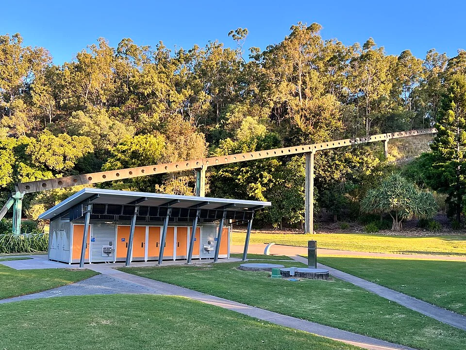
Australia’s National Public Toilet Map is an example of a service that provides more than locations. Its public information includes opening hours and types of facilities where those details are known. Its accessibility material explains some of the information users can look for and use when planning. The photograph for this article shows toilets in a park in Brisbane. It supplies a view of a real building, without serving as a current listing for that site. The difference between those two kinds of evidence is one of the things a good service map has to make clear.
Describe the last turn from a public route
A person following an overhead map may be sent toward the back of a building. Walk the route in your imagination from a nearby entrance to the park. Is the spur path visible from where the person would turn? Does the door face the place the map would bring them to? Can they reach the entrance without doubling back across a lawn or around a fence? This much can be described in a sentence alongside a location. The useful sentence names a feature the person can actually recognize, such as the signed path from a playground, instead of a direction taken only from the perspective of the map editor.
A wayfinding problem can change with the direction of approach. The door may be straightforward to find from a playground and difficult to understand from a car park. A path that remains visible in the distance can include a step or an unpaved stretch close to the end. If describing an approach, keep the starting point and actual route together. A broad statement that the toilet is near the entrance makes a poor distinction between several park entrances. Two simple directions for two common approaches can be much more useful than one statement intended to apply everywhere.
The most useful image can be a modest picture from the decision point. Photograph the building if it is suitable to do so, and then add enough of the foreground to identify how somebody would reach it. Avoid including bystanders or photographing users in a setting where they reasonably expect privacy. Public signs and paths can often be described adequately in words. Whether using a picture or a short description, start from the place someone needs to make a decision and preserve the reason the direction works.
A usable time includes the closing point
Counting hours sounds straightforward until the facility shares a location with another public service. A toilet can be inside a building with its own schedule. A building can close for maintenance while the paths around it remain open. A special event can make a usually available entrance difficult to reach. Put the time that applies to the facility itself beside the access information. If a listing was last verified a long time ago or availability varies with a surrounding building, show that relationship clearly. It lets a reader decide how much confidence to put in the time shown.
Suppose a person plans to visit a park for forty minutes in the evening. They need to know whether the facility will be available closer to the end of that interval, not just when they first reach the gate. A listing with an opening time and no known closing time does not settle the question. Mark a missing time as unknown and provide a way to check when one is publicly available. An invented closing time is likely to create a wasted trip. Clear uncertainty allows a person to make another plan without guessing what a blank field means.
Temporary information can be valuable when it is attached to an actual duration. A report that a corridor was closed on Tuesday is useful as an observation from Tuesday. It need not be interpreted as proof of a permanent condition. A service can separate a dated report from its regular hours and provide a way for the responsible party to update the listing. This is part of what makes a public map a service over time. It has work to do after the pins have all been placed.
Turn broad accessibility labels into details people can use
A person may need to know whether a usable route reaches the entrance, whether a specific feature is present inside, or whether a larger changing facility is available. Each item answers a different question. A label that says accessible can help narrow a search. It may be too general to choose between two otherwise comparable places. Australia’s service describes fields such as adult and baby changing facilities and some details of accessible toilets. A map reader can use that information to make a choice based on what the visit actually requires.
For someone recording a public facility, describe what you can verify and the source of the description. A door sign can identify the official designation. A current service record can supply more detailed features. Regular users who wish to give feedback can identify issues not evident on a short visit. Avoid turning a single inspection into a sweeping promise about who will be able to use the room. A practical description says what is present and whether the information is known. It can then be related to the needs of an individual or group without requiring them to explain those needs publicly.
A listing should also let readers distinguish the facility from its access route. A fitting inside the building can be suitable and still offer no benefit to someone unable to reach the door. A curb, a gate or a last stretch of gravel can determine whether the trip is possible. Describe a usable approach in addition to the thing at the end. When a route was not checked, keep that clear. A reader can then seek the particular information that matters instead of relying on a broad designation for the whole experience.
Make the next correction easier
A good record has a short path from discovery to correction. Put the facility’s name and location on any report and say which piece of information appears inaccurate. If the hours are printed on a sign, note the date and exact part of the schedule being described. If the sign refers to a nearby building, keep that relationship with the report. The person reviewing it should be able to decide whether a description belongs to the permanent record or to a temporary note.
Check the record from the other end as well. A reader arriving through a search result should be able to find the practical details without reading a long description of the park. Look for hours, approach and facilities together. Make the name and location sufficiently specific for a person to verify the entry with the service operator if they need to. A public map earns its place in someone’s day when it gives them enough information to decide whether this part of the trip will work. Much of the value is felt before they ever see the building.
Check the location when the connection is poor
Imagine that you can look up a route at home but lose a reliable connection after entering the park. A compact record with an address or named entrance can still be useful if it was saved beforehand. An entry that shows only a pin on an interactive map can be much harder to use in that situation. The location details should identify the destination in ordinary language and leave enough landmarks to make sense of an independent street map. The feature that matters here is the ability to keep using the information after the original display disappears.
It can help to present nearby facilities as meaningful alternatives rather than sort solely by straight-line distance. A toilet on the far side of a road or through a building can require a longer approach than another one a little farther away on the map. One can have known hours and another can lack that information. A useful comparison tells readers what is shared and where the evidence differs. It does not need to promise that one facility will be suitable for every person. It gives the person planning the trip enough information to decide which facts need a further check.
For a public agency publishing these records, try the service on an ordinary narrow phone screen. Make sure the place name, approach directions and hours can be read without the map covering them. Verify that any button used to report a change can be found beside the actual facility record. An update mechanism is more effective when a reader can name the right entry and explain the problem in a sentence, even after leaving the location. This is where maintaining the data and presenting it as a usable service turn out to be the same piece of work.