When a Trail Sign Comes Down
A repaired section of trail can change a whole walking route. The public notices that describe its reopening have to keep different places and dates straight.
In this story 4 sections
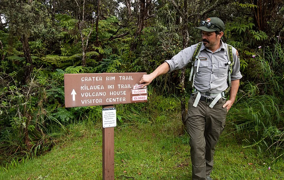
There is a satisfying moment when a trail crew removes a sign that has been telling people to stay out. The photograph accompanying this article shows that work at Kīlauea Iki Trail in Hawaiʻi Volcanoes National Park. A sign has a location and a face. Taking it down seems like a simple way to change the promise at one place. It can be harder to explain what has changed to somebody reading a park map in a different place, perhaps holding up a picture of another notice taken several months earlier.
The park’s September 2019 announcement reported that the full loop reopened after repair work. Part of the route had already opened earlier that year. Damage associated with the 2018 eruption and seismic activity meant other parts still needed work. These facts fit quite neatly in a short announcement once all are put into past tense. Before the last step, “the trail has reopened” could have meant something different from what a person who expected to finish the whole loop thought they heard. The earlier partial reopening makes this an unusually useful case for thinking about the public work a notice has to do.
Give the notice the length of the restriction
Begin with a simple loop rated as one walk on an ordinary map. Put an entrance at one point and a joining path somewhere toward the middle. If only the first section is available, a visitor may be able to walk to a marked place and return. The name of the first trail and its entrance have not changed. A closed section has still changed the route from a loop into a different kind of walk. In the notice, show whether visitors can continue as before, must turn around or have a choice of approach that remains available. Do not make people infer the shape of what they can use from the presence of one title on a long route.
This problem becomes more visible if a route keeps passing signs with the same title. A notice posted at one end can name the entrance from which a section is available. The next entrance might still be closed completely, because it connects only into another segment. On a small map, a general ring around the main trail name can leave that ambiguity unsolved. Better directions distinguish locations and endpoints in language the reader will have a chance to see again. Where a sign addresses only one approach, a notice online can explain the relationship to the others.
In an imaginary trail system, try giving two people directions from opposite ends of a closure. One starts before the damaged bridge, another on a route that joins after it. The safe instructions may both be simple once places are named; “walk toward the closure” is not a good summary of them. An official map can establish the available routes. Descriptive text can name what is fixed to each of the entrances. A photograph of an old notice is useful history, and should not have to provide the current directions on its own.
Date the decision, not just the report
A posted day can refer to a changing number of things. It may be the day officials closed a part of the trail, the expected date for repairs to end, the date of a new observation or the effective date of a reopening. A plan to finish is a different kind of evidence from a report that a route may be used again. Put the nature of the date beside the date itself. People forwarding a short version of a public update should include that wording because the month and day alone can be carried forward so easily.
After Kīlauea Iki had partially reopened, the September announcement could describe what remained closed and distinguish the subsequent complete reopening. An archived release of this kind gives you a particular point in that history. It does not say whether the trail is available now or establish that all nearby routes reopened at the same time. The date is useful exactly because it stops a reader from confusing the event with an advertisement. Someone planning to go there has a separate and time-sensitive question for the park’s current information.
In a staged reopening, there may also be unusual periods before arrangements return to what someone remembers. A route could have one new junction or a closed connection that matters to a relatively small set of visitors. A public authority may post longer information than fits on every physical sign. Keep the central fact simple while giving a reliable place to check the rest. Test how it reads to someone who saw neither the original closure nor the work. Those readers may make the most literal and revealing assumptions about what a word like open covers.
Explain the work without inviting a shortcut
A closure can be needed for damage, continuing work or concerns about unsafe conditions. The 2019 park announcement describes repairs where damaged sections and rockfall needed attention. Mentioning a cause gives a visitor a reason to take a restriction seriously and can make it easier to understand which part of a route is affected. It does not give a visitor a method for assessing whether they can pass without care. Closure information needs to reach people who might otherwise interpret a quiet stretch with no equipment visible as a newly available one.
An explanatory note should allow two things to coexist. There may have been considerable progress before the whole route became suitable for use. Someone may only be able to see a fraction of that progress behind a sign. A report can say which areas have reopened, which still require approved work and what event will cause the next public update. The public does not need guesses about the crew’s remaining time. It needs a description that does not change unhelpfully when a publisher uses a picture of a calm patch to illustrate an account of the whole park.
The notice is part of the work in another sense. After the decision to make a route available, people need to find that state on panels, map updates or online alerts. The crews removing physical signs and the staff updating information do not necessarily have the same locations before their eyes. List the important approaches and the places that carry the message. Giving the same location name to different documents helps someone checking them avoid concluding that two simultaneously visible notices refer to the same place when they do not.
The change can be checked at the other end of the information chain. Ask someone who has no inside knowledge of the park to find the update and explain the route they believe it makes available. If they can identify the location, date and exact scope but still miss a significant constraint, the update may have left an obvious connection out. You learn more by hearing which sign or page they actually used than by handing them the final approved wording.
It can also help to give staff a last small inspection after the public notice changes. At a major entrance an old sign might have been taken down promptly, with another still visible where a narrow approach joins farther in. Recovering the difference does not require another grand announcement. It does require a common list of locations and clarity about who can confirm what has happened at each of them.
Two visits require two kinds of attention
Imagine someone who came before the full opening. They could have followed an available part, returned to the point they started at and remembered a very incomplete loop. Now they see a photo of a small sign being taken down. On their next visit a good map should give them a way to recover the full layout without having to reconstruct the original problem. A person who has never visited needs to jump in at much the same place. Both will use a current map and whatever directions are posted. The history helps them understand change; it is not a substitute for the current decision.
Another useful check is to ask the difference between the trail with a certain name and the network of routes someone will actually use to get to it. An alert can be precise about the section where work occurred and still omit conditions at a road, trailhead or connecting path. If those places are managed separately, give the reader a way to check them. Someone using a route with limited alternatives benefits from knowing at the first decision where the appropriate information will come from. A general reopening announcement should not have to establish the availability of every supporting facility.
Return to the picture of the crew. The sign has accomplished its last task by being removed at the right moment. There are still people responsible for telling others that the path has changed and which part has changed. A date, a route and the scope of the decision can make a reopening understandable even to someone who has never approached the place from the same direction. That is the rest of the work the sign cannot do for them.