Where a Beach Mat Ends
An access mat can make part of the sand easier to cross. To know whether it completes a public trip, follow the route back to the entrance and forward to the place a visitor needs to reach.
In this story 4 sections
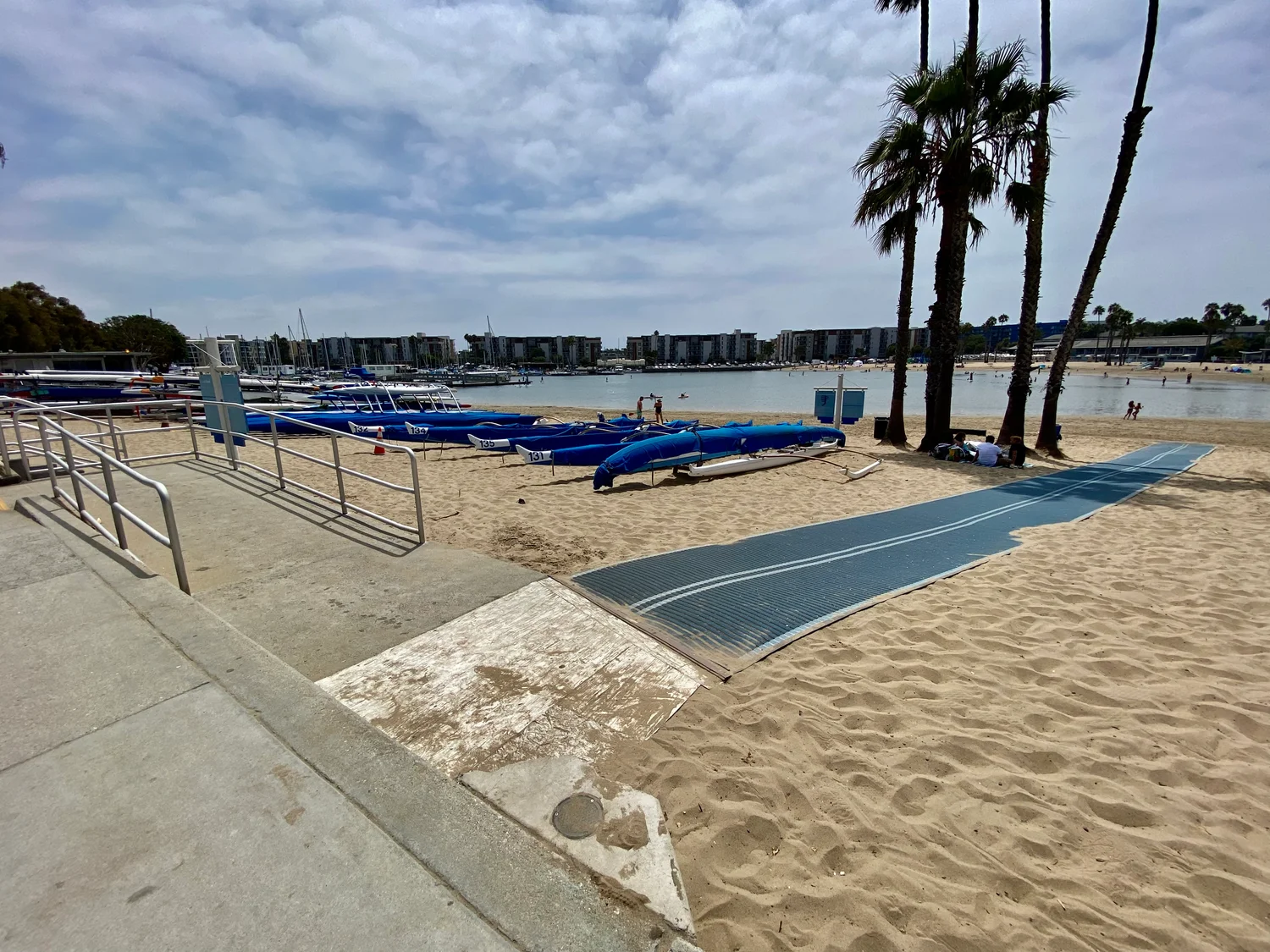
On the right of the Marina Beach photograph, a blue strip continues out across the sand. On the left, a paved ramp and railings show another way of approaching the beach. Seen at this distance, there is something wonderfully simple about a firmer surface laid where loose sand would otherwise interrupt a trip. The moment a visitor asks whether they can get to a particular place, the picture needs several more details. Where does the firm surface start? What meets it at the far end? Is there room to change direction at the join?
The Los Angeles County Department of Beaches and Harbors describes access mats as firmer paths across sand for people who need them, including users of mobility aids. Its Marina Beach page also describes a programme of improvements that includes a mat and other site amenities. The cover is an archival 2022 view, not a report on the current layout or a promise of present access. It gives a concrete example of why the paved approach, the mat and the intended destination are worth describing separately.
Moving across sand is only one part of getting there
A visitor can start at a car park, transit stop, pedestrian entrance or nearby facility. A map showing only the place where a mat lies is not enough to describe all the ways of reaching it. There may be a curb, a gate or a path with a surface that changes just before the mat begins. Someone who can cross the mat may still need to know which route provides an uninterrupted approach. Mark the starting point and describe what lies between it and the beginning of the adapted surface.
A drawing can make better use of an access symbol by pairing it with ordinary landmarks. A description can say whether the mat starts beside a ramp, picnic area or promenade. Keep the particular place clear enough that a visitor does not first have to inspect every branch off a path. When a venue has changed its layout, a dated view that identifies the current route can make a clearer guide than a generic image from elsewhere along the shore.
This is also helpful to family members planning a visit together. People arriving separately may choose different entrances without realising one of them cannot conveniently reach the place the others picked. A meeting point at a named feature is much better than the instruction to meet on the beach. A map that lets someone identify both a firm path and the spot they are meant to meet can reduce the need for improvised directions after arrival.
There is no single destination called the beach
One visitor wants to reach a view. Another wants to join friends on a portion of the shore. A third needs to find a route to a beach facility. The same strip of mat could be useful for each for a different portion of their trip. It does not necessarily reach every destination or provide access into the water. County guidance and the site's current information can explain the services at a given location. Avoid treating a photo of a surface as evidence that a particular water entry is available or suitable.
Describe the endpoint explicitly. If a path ends in sand some distance before another facility, say so. If there is a turning or viewing area, mark where and on which surface it sits. When published measurements are available, attach them to a dated description rather than estimate a distance from the image. These details help a reader decide whether an advertised feature supports the trip they have in mind. A short note about the end of the mat can be as valuable as a photograph of it running into the distance.
Room alongside the route matters as well. A mat can say go this way without offering much space to stop. A visitor may need somewhere to wait with others, make a turn or let someone pass. That area does not have to look identical to an unoccupied beach in a brochure. To decide whether it works, look at where people and objects accumulate when the place is busy. The surface has a role, and space at its edge gives a person other choices.
Give changing conditions their own source
A beach surface is exposed to changes over time. Sand may gather near a join, a route may be adjusted or a service may not be available throughout the year. It is helpful to distinguish the plan of an installation from the conditions reported on a given day. A dated official page or notice can do that work if the reader is told what it covers. A map that marks the durable locations of facilities need not pretend to be a live inspection.
Los Angeles County presents a map of resources such as access mats and beach wheelchairs. Those are different forms of help and may have different local arrangements. When a trip depends on one of them, consult the relevant site's current instructions and contact channel. A photograph of a ramp cannot establish that a particular aid is available. Conversely the fact that another site provides an aid does not show what approach from the entrance is usable. Each facility or service answers a narrower question.
A useful maintenance report can name which join or portion of the path is involved. Saying that a mat appears covered at its first few metres is more informative than treating the whole beach as inaccessible from one observation. Give the location, the date and which route was attempted. Staff can use that account to check the condition and describe a change without having to infer which piece of equipment or path the visitor meant.
Read the photo as part of a route, not a promise
There is a useful difference between a direct way to the shoreline and a route that ends near a place to enjoy being at the beach. Some visitors may have no interest in going into the water. A usable route to a gathering point or a place to sit is valuable in its own right. Others may need equipment or access arrangements the mat was never designed to provide. Publishing the endpoint lets each person relate the installation to their own plan. An operator can list separate destinations without giving the impression that they all require the same route.
The map can make a similarly useful distinction between a ramp and a mat. A ramp relates places at different levels. A mat changes the underlying walking or rolling surface for a defined stretch. A beach with both may offer a trip in which those features meet. There may also be more than one way of going between pavement and sand. Giving the features their own names in directions allows someone to follow the relevant sequence rather than look for a sign promising only accessible beach without saying which element it refers to.
Another ordinary test is to read the map from the other end of the day. Can someone at the point where the mat ends find their way back toward the same entrance? Are the branches named from both directions? A person who finds the mat by following other people on arrival may want a more direct cue after a group leaves. A photograph looking one way is unlikely to supply that information. A sign facing both approaches or a map of a few simple landmarks can let the route work without requiring a visitor to remember each turn they made on arrival.
Changes to a route are much easier to explain when the latest notice says which part moved. If the terminal point is shortened, update the endpoint as well as any total length. If a different entrance leads to the updated path, make that visible before somebody sets out. Where no live status is available, giving a source for confirmation is still useful, provided that source is responsible for the actual site. This is how a visit can remain possible even when a particular archived image has stopped being useful as a guide.
Marina Beach's official account describes several amenities together with the access work. That can make the site easier to picture, but a list is not a route diagram. Whether two entries can be connected without crossing loose sand remains a question for the information and conditions at that location.
The image shows a striking difference between pale sand, paved approach and the coloured surface. Look for the boundaries rather than only the colour. Where the pavement stops, another form of support matters. Where the mat stops, somebody needs to know which kind of ground or facility they reach. That information can come from a map, the operator or a present observation. It is not all in the older photograph, however thoroughly someone inspects it.
A good description introduces the access mat as part of a real journey. It names the approach, the place available at the end and the source to consult if conditions change. Then the blue strip in the picture can do the job it does best. It shows one very visible response to a surface that otherwise stops some people short of the visit they came to make.