Where a Park Puts the Drinking Fountain
A public fixture can offer a drinking spout, a bottle filler or both. Its place on the path, the design of its controls and a useful maintenance record determine what it actually offers a visitor.
In this story 5 sections
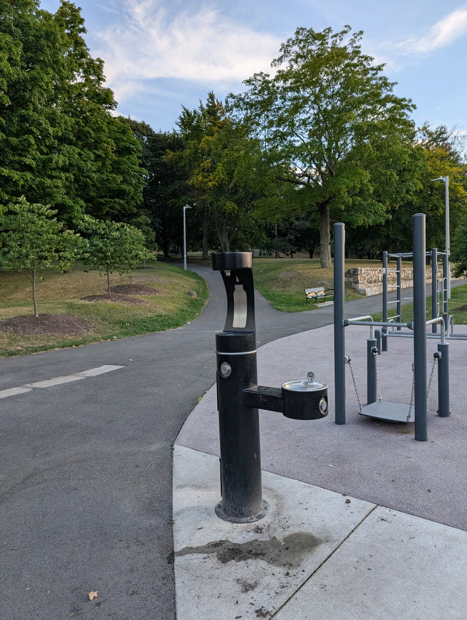
At a path junction, a person sees a dark post and a pair of small basins. It is a drinking fountain, but it may be more than that. One visitor needs an upward stream to take a drink without a container. Another wants an outlet with room underneath for a water bottle. Somebody who sees the map entry and walks fifty metres out of the way has a practical interest in the difference. The fixture is useful only if it supplies the kind of access the visitor thought was there.
The photographed unit is from a Boston park and includes a bottle filler as well as a drinking fountain. Another unit in another park might be drawn with the same marker. New York City's public dataset for park fountains, for instance, explains that one record can refer to a single fountain or to multiple attached fountains. Reading a map and looking at a fitting are different ways of identifying service. The picture tells us what is mounted on one post. The marker helps somebody locate a facility, but may need more detail to answer a question about one of its outlets.
Put it where using it does not block the path
Locating a fountain beside a heavily used route seems at first like a simple answer to the question of access. But people stop to operate it. A child may approach beside an adult. A person in a wheelchair may need room to turn before reaching the usable side. If the fixture is just far enough from the main path, people can wait without occupying the entire through route. If that small distance comes with an uneven strip or a change in grade, the shortcut is no shortcut for everybody.
Suppose a park has an oval path around a field, nearby benches and an entrance where several routes meet. A fountain at the entrance will be easy to describe. One near the benches can serve people who stay longer. One beside a popular crossing point may invite a queue in a place where traffic already narrows. The best fit depends on what visitors do when they reach the site. A dot drawn on an open patch of plan shows the location without depicting the space people need beside it.
A useful drawing can show both the footprint and a small standing or turning area. Record the approach people actually use, not only the nearest line on an abstract plan. If the fixture faces away from the route, a person might see its back for a while and not recognise it. A sign at a junction can help, but placement and orientation may solve part of the problem before a sign is needed.
The outlet and control get their own test
A small jet intended for drinking provides different clearance from a vertical outlet that lets somebody fill a bottle. New York State's guide for drinking fountains describes both and calls attention to the space needed to position a container. That requirement makes intuitive sense when you picture somebody trying to balance a large bottle under a short spout. It is the hand and bottle together that need room, not merely the water stream.
Controls are part of that geometry. An outlet can be visible while a push button is hard to reach from the side where the user stands. Compare where the body has to go, where the hand has to reach and where the water goes once released. A test with a drawing of the fixture is only a beginning. The actual object and approach can reveal obstructions a front view omits. A taller available outlet is not always an alternative to a lower one when the second was put there for a different user.
Some park fixtures include even more functions, such as an outlet placed for animals. Signs and maps that name them separately can help both visitors and staff. An operator might refer to a post as one asset while a user reports one outlet out of several. A practical record allows both descriptions to be true. A visitor who only needs to fill a bottle and a visitor who needs a usable drinking spout can draw different conclusions from the same repair report.
A failure in one part is not the same as no water anywhere
A Boston 311 record for a different fixture at Herter Park illustrates this distinction. A report described a problem with the drinking function while other outlets at the same fixture were working. The report records what someone said they observed at the time. It is not a present inspection or a statement about the fountain photographed here. Its value as an example is the specificity: it names the outlet that could not be used and distinguishes it from the rest of the station.
A report can make this easier for a maintenance team by identifying a nearby path junction or another visible feature as well as the park name. Parks can contain more than one fountain, and a numbered asset or clearly marked location helps the right visit happen. Describing what the control did is more informative than trying to diagnose the plumbing. No response, a weak flow and a leak on the path could lead to different investigations. The person who reports a fault can provide an observation without having to find the component that caused it.
Another useful field is the date and approximate time. A fixture observed inactive during a maintenance visit or a seasonal shutdown is different from a fixture that fails in a period when it is supposed to be available. An operator can compare the report with its schedule and verify the current condition. A system that marks all such reports as proof of an identical breakdown would send people to the wrong part of the problem.
Some map entries need a season as well as a place
The state guide notes that exposed installations can be designed for freezing conditions or arranged for seasonal shutdown and drainage. Local practice will depend on the fixture and operator. For a visitor the practical consequence is simple: a point shown on a map is not always available every day of the year. A date on a public notice or a separate status field can be more helpful than leaving someone to guess when an outdoor fixture was last checked.
It is useful to distinguish an asset map from a service guide. An asset map can appropriately show a fixture that remains installed while out of season. Somebody inspecting infrastructure still wants to know that it is there. A guide presented as a way of locating a currently usable fountain needs clearer status information. The same data can support both products if its purpose and limitations are stated. Otherwise a consistent pin might be read as a promise the map's editors never intended to make.
A small notice at a closed outlet can also answer a question a map cannot. It may name the reason it is unavailable, give an official channel for an update or identify another facility where that information is known. The absence of a sign does not establish that the outlet is approved for drinking or operating normally. Those are matters for the park or water service to confirm, rather than to infer from the presence of a basin.
Read the service from the visitor's end
A park may be able to make an existing fixture easier to use without replacing it. If people regularly come to the back of a two-sided unit looking for a filler, a small marker at eye level may solve a problem of visibility. If the edge facing the path offers no room for a wheelchair, a marker cannot create that space. Observe the unsuccessful attempts separately. A budget directed only to signs may help the first visitor and leave the second with the same problem.
For map editors, a photograph paired with the asset record can explain which side has which function. It should be dated and need not become a claim that the whole unit is still working. More than one field can be true: the station exists, it includes a specified outlet and a recent check has or has not confirmed availability. Keeping those facts separate saves a future editor from concealing a useful location merely because its operating condition is uncertain.
An ordinary test starts with an empty bottle or a person without one, then follows the route to the actual fixture. Can the facility be found? Is there room to approach? Is the intended outlet apparent before a visitor reaches for a control? When a service fails, does a person know how to describe where it happened? Those questions are useful before buying another unit and after the first ones have been installed. They separate visibility, use and maintenance instead of asking one map symbol to stand for all three.
The person who pays attention to those distinctions sees more than a tidy post at the side of a path. They see small choices that make a place easier to stop in: accessible room beside a route, a useful clearance under a nozzle and a way to tell the operator which part has stopped working. A drinking fountain takes up little space on a plan. Its real place is the bit of ground a visitor has to cross and the moment in which a simple action becomes possible.