Who Looks After the Tree Pit?
A sidewalk tree is easy to put on a map. Keeping its patch of ground useful requires a record of what the city, a contractor or a volunteer can actually do.
In this story 4 sections
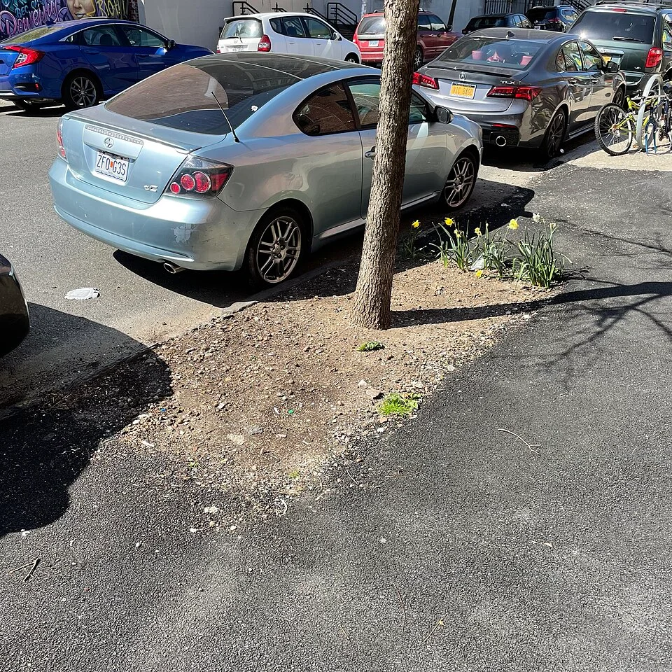
The square of ground in a city sidewalk often has a less conspicuous history than the thing growing out of it. Someone knows when the tree was planted. A map may give it a name and a point near an address. People who pass it on foot may know that bottles tend to collect on the curb side or that a corner feels dusty on warm afternoons. Each of them can take a fairly precise bit of evidence home. None of those bits alone answers a simple question from a neighbor: whom should they ask if the little square of ground needs attention?
A street tree sits where public systems and private routines meet. A planting agency or contractor may have specific responsibilities. A block association may organize activities within the program’s rules. A nearby shop can see changes precisely because its door opens across the pavement. A job such as reporting damage can start with a neighbor and continue with a person who has authority to decide what work is appropriate. Getting the roles clear helps preserve the effort residents do already without guessing at who owns a particular decision.
Identify the tree and the work separately
New York City’s public tree map gives individual trees records. A display can tie an item to an address or map position, bring up information about the kind of tree, and in appropriate cases make room for recorded care activities. It is a starting point for keeping observations about a tree from drifting to its neighbors. A public inventory can also age. An old point may be near an empty space, a recent planting or another tree from the same project. If you are at the site, say what you actually see as well as what the record says.
This distinction has a practical effect. Reporting an overflowing bin next to a tree is not necessarily reporting a damaged tree. The problem may involve a loose object, a broken guard, missing soil around a trunk or damage associated with street work. Give the two jobs their own names when they are distinct. An address and a short description of what happened are often more useful than the confident assignment of a cause. An obstruction in a walking route deserves description of where it is, even if a tree is the easiest landmark.
There is also a difference between marking a thing as absent and proposing to replace it. If a tree is missing from its former spot, the condition is observable. Selection of a new tree and the position in which it could be planted involve separate work. Space below the surface, distance to other fixtures, room for root growth and approval of a site can matter. Some of those conditions are invisible from above. Keeping the observation separate from the proposal makes it possible to record the first without preempting the people who must examine the second.
The space below belongs to the surface above
A passerby may think the tree pit is wasted sidewalk, especially when the space seems to be collecting litter. A pit can provide an exposed area through which water and air reach soil. The location of the curb and the walking route matter on the other side of the problem. A guard that takes more space than a pedestrian can give up can create an access issue, while the wrong covering can change what happens just below the surface. A well-meant attempt to tidy up the square deserves caution if it would also change the soil, surround the trunk or create a lasting barrier in the sidewalk.
Notice where people and water tend to go in ordinary conditions. A path of densely compacted ground may show that pedestrians have found a shortcut. A hard material installed beside a tree may make the opening seem wider in photographs than its useful soil surface would suggest. You can record those differences from public walking space without digging, removing fixtures or testing the trunk. If an issue will affect the tree or require physical work in the street, ask the responsible department how it should be addressed.
Think about the spot as a micro-sized area shared with everything that uses the block. It is common to concentrate on the trunk and let the sidewalk become an undifferentiated strip around it. If somebody must maneuver from a door into the main walking path, an object protruding at the edge of the pit can matter very quickly. The person reporting it should be able to specify the route and the location. If a maintenance crew visits at a quiet hour, a photograph or simple sketch of where the conflict arises can give that crew information it cannot get by looking at the trunk.
Care takes more than a visit
The NYC Parks planting standards illustrate that a newly planted tree can come with obligations for care after work has finished. The document discusses activities including watering and maintenance under its stated arrangements. This is a different perspective on how an installation succeeds. The moment when someone photographs a new tree has only some bearing on what the place will be like two summers later. Watering and observing conditions can be regular tasks. Other work has to be authorized and may need skills or equipment beyond those of a volunteer. Read the current requirements for the place and planting in question before deciding who will take on each role.
A volunteer program can be organized around a simple piece of information: what attention, if any, did this tree receive recently? A willing neighbor who never hears about a preceding visit might repeat something the group already did or overlook a tree everyone assumes another person reached. A log does not need to identify every resident on the block. Label the tree, the date, what happened and any observation that calls for follow-up. If multiple groups use the same address as a landmark, add a location visible from the street that distinguishes one planting from another.
Some sites are much more difficult to look after in practice than they seem from a signup. The person who offered to check a place nearby might not have a safe way to stop beside it. A week with sustained rain can change what is needed. A lock, temporary construction or a changed opening schedule might make routine work impractical at particular times. These are reasons to check conditions with the relevant program and to provide a way to report an exception. It is easier to change one assigned visit before it fails consistently than to recreate a whole season’s record afterward.
A new map entry can give an impression of precision that the activities behind it do not necessarily share. The planting date may come from a work record. The condition may come from a different survey some time later. A note of a new stake or temporarily fenced area may be a same-day observation by a constituent. Put dates next to these facts instead of assuming any detailed entry was checked altogether last week.
There is also a reason to close the loop after a repair. If someone changed or removed a fixture, the next person who looks up the location needs to know whether their report concerns the same condition. An old issue marked as resolved and a fresh observation of the same problem can sit together without contradiction. A timeline helps show the difference.
What to take to the next conversation
At a meeting about a sidewalk planting, keep an observation, a question and a proposal in different entries. “There is a gap between the grate and the main walking route” is an observation if you can identify the location. “Who services the grate?” asks for responsibility. “Replace it with an approved alternative” is a proposal that needs a different kind of answer. It is reasonable to put all three on the same sheet. The distinction gives someone a chance to help with the first two before they have enough information to judge the third.
If a map provides a record of an individual tree, reference that record along with what you saw. If the link shows a different location, say so without jumping to the conclusion that the entire map is unreliable. A small numbering or address error matters when somebody dispatches a crew. Recording it makes the problem available to be checked. Give the location information in a form that survives forwarding, such as street name and cross streets, rather than asking a later reader to depend on the original map view staying open.
A short comparison in the field is often useful. Walk the same block after another period of weather or once ordinary street work has finished. Has the same object remained? Can people now pass without stepping close to the pit? The changed aspect might belong to the setting rather than the tree. An inventory gives the observations an anchor, and a neighbor with knowledge of the block gives them a time and a person to ask. The square of dirt starts to look less like the leftover space between a tree and a curb. It becomes a clearly located part of the street for which different people can take useful, intelligible responsibility.